


The Camps : THE SURVEYOR'S OFFICE
The camp surveyor has an essential position in the logging camp. They mapped the land, ensuring that a company was logging their own timber rights and not moving in another companies spot. They marked out roads and rail lines connecting the camp to communities and, most important, to the candy-side, the choice logging sites.
The surveyor was not an inkslinger and could be found trudging through the wilderness in summer marking trees or snow shoeing or skiing in the winter to plan a road through the forest.
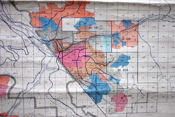
With the field work complete, a surveyor would be ready to map the results on heavy brown paper, 3 feet wide (about one metre). They would use a T-Square and protractor to create their own 400:1 topographic map. These maps would outline the camp, rail lines and other features.